Scientists call this ‘rapid intensification’. As the planet warms, this violent strengthening is becoming more common. These storms are especially dangerous as they often catch people off guard. That’s because forecasting rapid intensification, although improving, remains a huge challenge.
Better forecasting will depend on more detailed monitoring of a hurricane’s inner core—especially close to the eyewall (see Figure), where the strongest winds occur—and on higher-resolution computer models that can better capture a storm’s complex structure. New machine learning (AI) techniques may help but are largely untested.
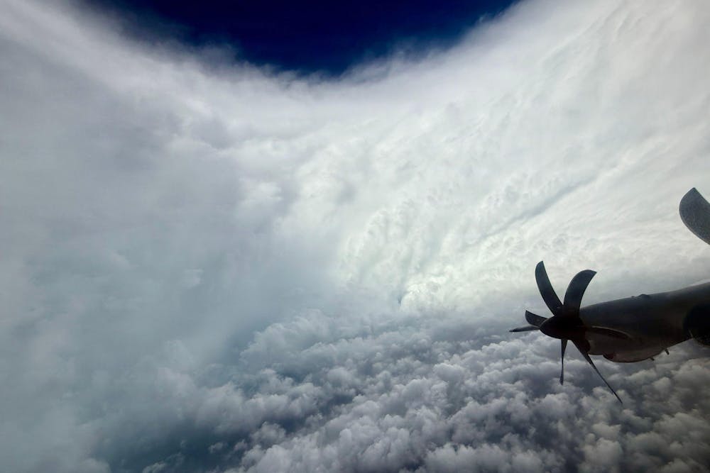 Figure | Inside the eye of Hurricane Melissa. Photo taken by U.S. Air Force ‘Hurricane Hunters’. Photograph by Lt. Col. Mark Withee/USAF/UPI/Alamy.
As things stand, rapidly intensifying storms mean that communities are often provided little warning to evacuate, and government agencies may have little time to make preparations, such as opening evacuation shelters or preparing critical infrastructure.
That’s what happened with Hurricane Otis in Mexico in 2023 and Typhoon Rai in the Philippines in 2021. Both rapidly intensified shortly before landfall, and hundreds of people died because they were unable to reach safety.
Fortunately, the chance of Melissa reaching category 5 was forecast sometime before it made landfall, helped by the storm moving very slowly towards Jamaica.
Perfect storms
A particular set of conditions are required to fuel rapid intensification: high humidity in the atmosphere, low wind shear (the change in wind speed with height), and warm sea-surface temperatures. Recent research suggests that, since the early 1980s, warmer seas and a more moist atmosphere means these conditions are becoming more common. These trends can’t be explained by natural variability. It seems human-caused climate change is significantly increasing the probability of rapid intensification.
In the case of Melissa, the fingerprints of climate change are visible on many of the factors that made it such a devastating storm. Sea-surface temperatures in the region are currently more than a degree above normal—conditions that may be 500 to 800 times more likely due to climate change. Warmer seas provide extra energy for a storm’s intensification. Rising sea levels also mean storm surges and coastal flooding are more severe.
Scientists are confident that rainfall is increasing as a result of climate change, because a warmer atmosphere holds more moisture, a trend evident in the North Atlantic. Melissa is travelling slowly, which leads to higher rainfall totals over land. Forecasts predicted mountainous regions of Jamaica could receive up to a metre of rainfall, raising the risk of severe flooding and landslides.
Some studies even suggest climate change is slowing down the speed of cyclones themselves (the rate at which the whole storm moves). This would mean they linger over land and dump more rain. Simulations by a colleague of ours at the University of Reading confirmed that past hurricanes striking Jamaica would produce more rainfall in today’s warmer climate.
The growing tendency for storms to rapidly intensify is helping more of them to reach the strongest categories, and that can be deadly when this surge in strength is not well forecasted. As the planet warms, this risk will only grow. That makes it crucial for scientists to improve hurricane monitoring and forecast models, as well as for emergency responders to prepare for the scenario of an intense hurricane arriving with little time to prepare.
Hurricane Melissa has brought the risks into sharp focus: storms are intensifying faster, hitting harder and giving people less time to escape. ♦
Author’s note
This article was written with Prof. Liz Stephens (University of Reading and Red Cross Red Crescent Climate Centre) and originally published in The Conversation with additional graphics and under the title ‘Hurricane Melissa is a warning—why violent storms are increasingly catching the world off guard’. At the time of writing, this article had been shared1,2 by Jagan Chapagain, Secretary General and CEO of the International Federation of Red Cross and Red Crescent Societies, and republished under the CC BY-ND 4.0 licence by:
UN Office for Disaster Risk Reduction (PreventionWeb)
Red Cross Red Crescent Climate Centre
Connecting Research (University of Reading)
Weather and Climate @ Reading
Yahoo! News
IOL
ScienceAlert
Europe Solidaire Sans Frontières
Press Trust of India
BizzBuzz
Tolerance
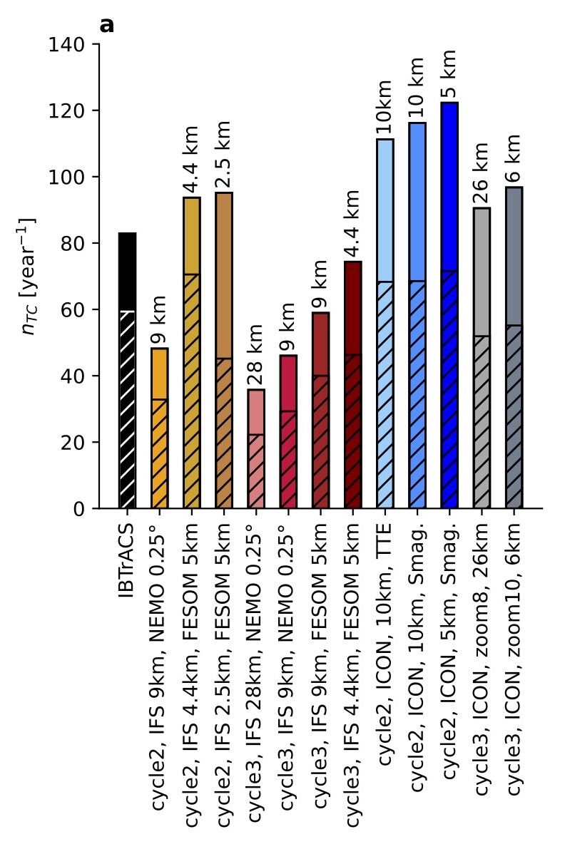 Figure 1 | Annual-mean tropical cyclone frequency (“nTC”) in observations (“IBTrACS”) over the period 1980–2022 (black) and nextGEMS simulations performed in model-development cycles 2 and 3. Bars represent global frequency and hatched areas represent the Northern Hemisphere. The atmospheric resolution is indicated above each bar.
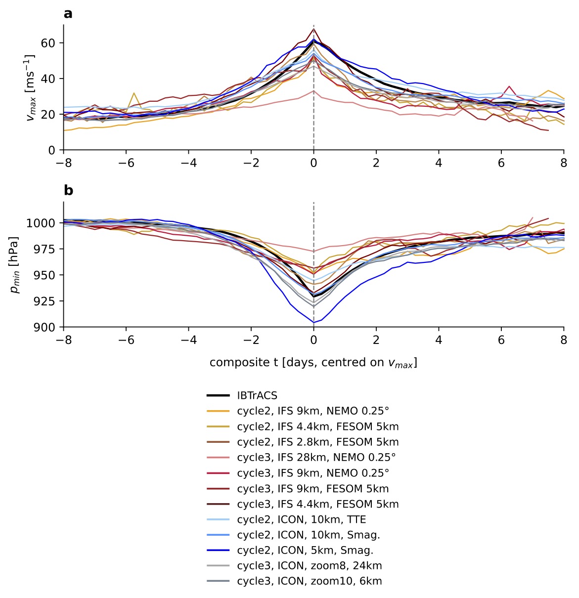 Figure 2 | Tropical cyclone intensity in the days before and after their peak intensity (indicated by the grey, dashed line) in IBTrACS observations over the period 1980–2022 (black) and nextGEMS simulations. Two measures of cyclone intensity are shown: (a) maximum wind speed (“vmax”) and (b) minimum central pressure (“pmin”). This analysis was performed for the strongest ten percent of both observed and simulated cyclones.